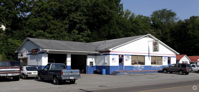
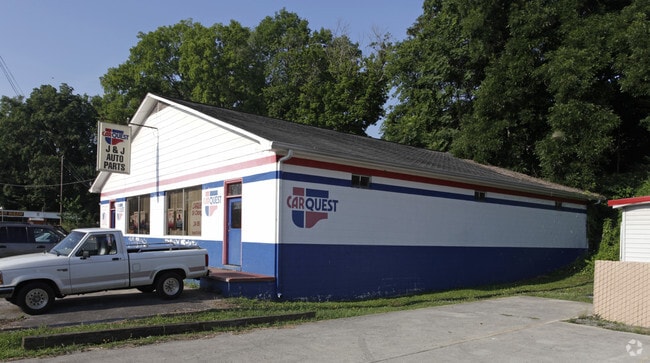
Property Record
1011 N Main St, Sweetwater, TN 37874
NEARBY LISTINGS FOR SALE OR LEASE
-
-
View all Sweetwater listings for sale on LoopNet.com
Property Detail
1011 N Main St
Storebuilding
DISTRICT: 01, COUNTY AREA: A01
AE
Monroe
47123C0127D
Tennessee
0
0.49 AC
2025
Tennessee East Area
925200
Other Market Areas
4,650 SF
023F-J-007.00
DEMOGRAPHICS near 1011 N Main St
1 Mile
3 Mile
5 Mile
2024 Total Population
3,744
9,673
13,628
2029 Population
4,068
10,482
14,741
Pop Growth 2024-2029
+ 8.65%
+ 8.36%
+ 8.17%
Average Age
41
42
42
2024 Total Households
1,477
3,859
5,365
HH Growth 2024-2029
+ 8.67%
+ 8.34%
+ 8.15%
Median Household Inc
$50,891
$38,045
$42,345
Avg Household Size
2.40
2.40
2.40
2024 Avg HH Vehicles
2.00
2.00
2.00
Median Home Value
$146,720
$152,627
$155,982
Median Year Built
1980
1987
1989
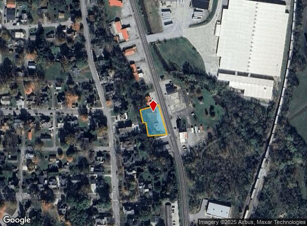
Nearby Places
Map Layers
Map Styles
 Street
 Aerial
- Restaurants
- Banks
- Shops
- Fitness
- Groceries
PUBLIC TRANSPORTATION
AIRPORT
McGhee Tyson
DRIVE
WALK
Distance
McGhee Tyson
56 min
45.9 mi
Freight Ports
Georgia Ports - Savannah
DRIVE
WALK
Distance
Georgia Ports - Savannah
470 min
410.1 mi
SALE & LEASE HISTORY
LISTING DATE
SALE/LEASE

May 24, 2022
For Sale
Aug 16, 2018
For Sale
Nearby Properties
Address
Land Use
TOTAL SIZE
Lot Size
Zoning
Address
Land Use
TOTAL SIZE
Lot Size
Zoning
714,000 SF
38.08 AC
Address
Land Use
TOTAL SIZE
Lot Size
Zoning
153,877 SF
25.93 AC
Address
Land Use
TOTAL SIZE
Lot Size
Zoning
4,950 SF
9.05 AC
Address
Land Use
TOTAL SIZE
Lot Size
Zoning
72,500 SF
11.96 AC
Address
Land Use
TOTAL SIZE
Lot Size
Zoning
33,288 SF
8.30 AC
R2
Address
Land Use
TOTAL SIZE
Lot Size
Zoning
17,586 SF
Address
Land Use
TOTAL SIZE
Lot Size
Zoning
170,598 SF
30.44 AC
M2
Address
Land Use
TOTAL SIZE
Lot Size
Zoning
103,621 SF
11 AC
M2
Address
Land Use
TOTAL SIZE
Lot Size
Zoning
95,224 SF
8.21 AC
C3
Address
Land Use
TOTAL SIZE
Lot Size
Zoning
28,120 SF
10.90 AC
Address
Land Use
TOTAL SIZE
Lot Size
Zoning
17,540 SF
7 AC
C3
Address
Land Use
TOTAL SIZE
Lot Size
Zoning
91,250 SF
12.74 AC
Address
Land Use
TOTAL SIZE
Lot Size
Zoning
44,485 SF
4.05 AC
Address
Land Use
TOTAL SIZE
Lot Size
Zoning
1,350 SF
32.20 AC
M1
Address
Land Use
TOTAL SIZE
Lot Size
Zoning
15,066 SF
2.27 AC
C3
Address
Land Use
TOTAL SIZE
Lot Size
Zoning
35,752 SF
1.74 AC
C5
Address
Land Use
TOTAL SIZE
Lot Size
Zoning
11,359 SF
2 AC
C5
Address
Land Use
TOTAL SIZE
Lot Size
Zoning
3,422 SF
16.48 AC
Address
Land Use
TOTAL SIZE
Lot Size
Zoning
28,207 SF
5.10 AC
C3
Address
Land Use
TOTAL SIZE
Lot Size
Zoning
24,513 SF
0.72 AC
C2
Address
Land Use
TOTAL SIZE
Lot Size
Zoning
31,551 SF
1.67 AC
R2
Address
Land Use
TOTAL SIZE
Lot Size
Zoning
30,504 SF
15 AC
M2
Address
Land Use
TOTAL SIZE
Lot Size
Zoning
130,594 SF
7.75 AC
M2
Address
Land Use
TOTAL SIZE
Lot Size
Zoning
139 AC
R2
Address
Land Use
TOTAL SIZE
Lot Size
Zoning
27.60 AC
R1
Address
Land Use
TOTAL SIZE
Lot Size
Zoning
22,800 SF
0.94 AC
C4
Address
Land Use
TOTAL SIZE
Lot Size
Zoning
5.51 AC
R2
Address
Land Use
TOTAL SIZE
Lot Size
Zoning
26,906 SF
2.84 AC
M2
Address
Land Use
TOTAL SIZE
Lot Size
Zoning
5,470 SF
2.20 AC
C3
Address
Land Use
TOTAL SIZE
Lot Size
Zoning
3,869 SF
1.76 AC
C5
The World's #1 Commercial Real Estate Marketplace
Connect with us
© 2025 CoStar Group
The information above has been obtained from sources believed reliable. While we do not doubt its accuracy we have not verified it and make no guarantee, warranty or representation about it. It is your responsibility to independently confirm its accuracy and completeness. Any projections, opinions, assumptions, or estimates used are for example only and do not represent the current or future performance of the property. The value of this transaction to you depends on tax and other factors which should be evaluated by your tax, financial, and legal advisors. You and your advisors should conduct a careful, independent investigation of the property to determine to your satisfaction the suitability of the property for your needs.